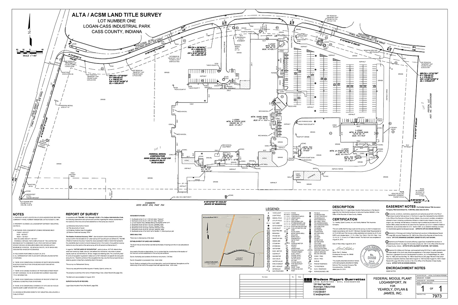
ALTA/ACSM Land Title Surveys
ALTA surveys are original or retracement boundary surveys conducted in accordance with the "Minimum Standard Detail Requirements for ALTA/ACSM Land Title Surveys". Lenders and Title Companies often require extensive surveys of commercial properties for the purposes of insuring title to real property free and clear of survey matters. The ALTA standards were developed to meet these needs in a manner that is accurate, complete and uniform. The complete 2016 Minimum Standard Detail Requirements for ALTA/NSPS Land Title Surveys can be viewed here.
ALTA surveys are generally requested for commercial properties. However, they can be beneficial when residential property is being transferred. An ALTA survey includes all aspects of a boundary survey and a property survey, in addition to depicting exceptions from coverage shown in the title commitment under schedule B-II. This means that all easements of record are provided to the surveyor by the title company, and are shown on the face of the survey. An ALTA survey can also show the location of above ground, visible utilities and the position of improvements with respect to applicable municipal building setback requirements. An ALTA survey gives a potential buyer the most complete picture of the property by depicting improvements, possible encroachments, encumbrances, zoning setbacks, gaps or overlaps in title between the subject and adjoining properties, record and visible means of access, record easements and the evidence of their use, lines of occupation and detailed descriptions of corner monumentation.
Boundary Surveys
Through the course of performing a boundary survey the property boundaries are established, corners are physically marked, subject and adjoining deeds and physical possession are evaluated, subdivision plats and historic surveys are reviewed and the surveyor renders a professional opinion as to boundary locations and conflicts. Pricing varies by location, size, and complexity of the deed.
These surveys should be completed before constructing a new building, new fence, or other major improvement. Corners are set, and lines may be staked when requested. Boundary surveys report conflicts found with adjoining properties, such as fences or buildings that are across property lines. They also report conflicts between deeds. A boundary survey is generally the first step in solving disagreements between neighbors regarding property lines, and are the basis attorneys work from.
The finished product for a Boundary Survey includes the physical monumentation of boundary corners, a plat of survey and a report of survey, both of which will be recorded if the survey is substantially at variance with prior evidence or if an original survey was performed.
Topographic Surveys
Topographic surveys depict the horizontal and vertical relationship of the ground surface and existing features. They are primarily distinguished from other maps by the representation of the ground surface using contour lines. Typical information shown on a topographic survey drawing include natural features such as trees, vegetation, hills, valleys, streams, and manmade features such as buildings, streets, sidewalks, curbs, manholes, catch basins, utility poles, underground utilities, above ground utilities, fences, retaining walls, ditches, embankments, field divisions, and ponds.
The purpose of most topographic surveys is to serve as a base map for the design of new features such as roads, driveways or buildings. It is often necessary to show boundary lines and easement locations in addition to existing site features so that they can be taken into account during the design process. Elevations on a topographic survey can be based on an assumed vertical datum or a published reference datum, depending upon the needs of the end user.
Lot Stakes
Lot stakes are performed in platted subdivisions for the purpose of constructing improvements such as fences, buildings or walls. Corner monuments are found or set and lines will be staked if requested by the client. Provided the land surveyor has found acceptable location of the boundary location, no survey drawing or report of survey is prepared. This type of survey is most useful in modern subdivisions where no conflicts with adjoining property owners are anticipated.
Property Surveys
Property surveys encompass all of the aspects of the boundary survey while also noting or depicting the position of boundaries with respect to physical improvements (such as homes, driveways, barns and garages). If the property is located in a subdivision, platted building setback lines and easements will also be shown on the survey. Recorded easements will not be evaluated for this type of survey unless documents are provided by the client. Upgrading a residential boundary survey to a property survey will cost from $100 to $300 depending on the density and nature of interior improvements that must be located.
Mortgage Surveys
Mortgage Surveys (also called Surveyor Location Reports) are performed specifically for mortgage lenders or title companies. These surveys generally map the house and buildings on a property to ensure they are on the property being financed. No boundary lines are established and no monuments are set.
The purpose of this type of survey is to make sure the house or other buildings are actually on the land the owner is purchasing. They are only intended for mortgage lenders and title companies. These surveys are of limited accuracy, and specifically state that they should not be used to determine property lines or to add improvements such as fences or new buildings. When a house or building is found to be close to a line, an actual survey is recommended by the surveyor.
Control Surveys
A control survey determines high accuracy horizontal and/or vertical coordinates for a network of physical monuments to which subsequent surveys can be adjusted. Control surveys are imperative when performing large scale surveying projects.
Retracement Surveys
A retracement survey is a type of boundary survey. According to Indiana Administrative Code 865 IAC 1-12-2(i) a retracement survey is "a survey of real property that has been previously described in documents conveying an interest in the real property."
Original Surveys
An original survey is a type of boundary survey. According to Indiana Administrative Code 865 IAC 1-12-2(f) an original survey is "a survey that is executed for the purpose of locating and describing real property that has not been previously described in documents conveying an interest to the real property."
Route Surveys
According to Indiana Administrative Code 865 IAC 1-12-2(k) a route survey "refers to surveys executed for the purpose of acquiring an interest in the tracts of land required for the following:
- Highways
- Railroads
- Waterways
- Pipelines
- Electric Lines
- Any other linear transportation or utility route
The term does not include surveys executed for acquisition parcels that are of even width and immediately adjacent to an existing title, easement, or right-of-way line and do not require a property survey in order to prepare an accurate legal description for the parcel. Route surveys are not considered either original or retracement surveys."
Route surveys are generally performed at the request of governments, railroads, local municipalities or utility companies in conjunction with the preparation of exhibits and legal descriptions for easement acquisition.
Aerial Control Surveys
In order to map a project using photogrammetric or LiDAR methods, a ground control network must first be established. An aerial control survey differs from a control survey in that the high accuracy monuments that are established are visible from the air.
Construction Surveys
Construction surveys facilitate the process of constructing improvements per design specifications. The construction surveyor ensures that improvements are placed correctly in relation to other site features by accurately setting stakes and grade stakes and by checking such items as plan dimensions, horizontal and/or vertical positions and drainage patterns.
Construction surveys may also include an element of as-built data collection during the course of the construction project in order to map the location of improvements such as underground utilities for future reference.
Residential and Commercial Subdivision Plats
The subdivision of land requires the services of a professional surveyor. Each county and/or municipality has a set of ordinances in place to regulate the subdivision of land. Depending on the jurisdiction of the property and the number of new lots being created, the process can require a combination of the following:
- A complete boundary survey of the land to be subdivided
- Coordination with the appropriate government offices (highway department, planning/zoning department, building department, county recorder, county surveyor, etc.)
- Topographic information depicting existing site conditions
- Legal notifications (published locally and/or mailed to affected property owners)
- Presentation to local planning commission
- The preparation of new legal descriptions
- The preparation of a plat to be recorded in the county courthouse
Elevation Certificate
An elevation certificate verifies the elevation data of a structure on a given property relative to the ground level. The elevation certificate is used by insurance companies to rate flood insurance policies, and is required by many companies before flood insurance will be issued.
Indiana Classified Forest Survey
In order to place property in Indiana's classified forest program, the landowner must designate an area of at least 10 contiguous acres of forest or wildlife habitat. A portion of the classified forest application, including a description of the land being classified, must be completed by a professional surveyor. The description is usually prepared using the record information contained in the deed of the property in conjunction with an aerial photograph depicting the proposed location of the classified land. The cost of preparing a classified forest survey application ranges from $400 to $650 depending on the size and location of the property and the immediacy of the project deadline.